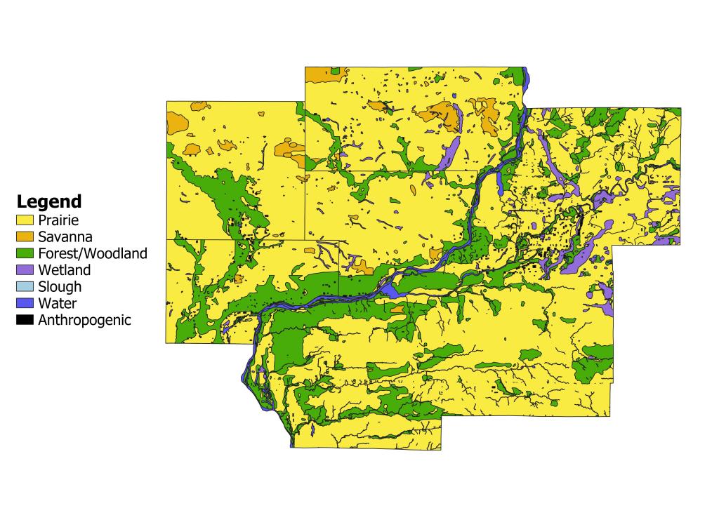
As the fertile prairies, woodlands, and wetlands of the Midwest opened up for Euro-American settlement, the US government set out to survey and map the land. Government surveyors established grid systems to divide or “plat” the landscape into properties which could then be sold. In addition to mapping, surveyors recorded a plethora of information pertaining to natural features (i.e., the presence and extent of timber, prairie, wetlands, streams, rivers, lakes, ponds, geologic features, etc.). In the case of Illinois, land surveys began in 1804 and ended around 1843. For Iowa, land surveys did not begin until 1832 and continued until 1859. The above map is a generalization of land cover data collected by these government land surveyors which is now publicly available as geospatial-referenced shapefiles. Their records are one of the best sources of information we have for understanding the pre-settlement vegetation of our region, let alone the Midwest as a whole.
It should be noted that I took the liberty of combining some landcover types into these categories in order to provide a coarse, big picture view of the vegetation of the QC Region during the early 1800s (click here for discussion on how I am defining the region). For example, the wetland category includes marsh, swamp, slough, as well as springs. The forest category, however, exclusively shows areas mapped as timber, and prairie only shows areas labeled “prairie” and “wet prairie.” Scattered trees/prairie includes cover types such as barrens, groves, oak openings, and thickets, all of which generally signify natural communities that form where prairie and forest intermingle.
Patterns in Pre-settlement Vegetation
Several patterns appear when studying the above map. Perhaps most striking is the dominance of prairie which accounts for roughly 2/3 of land area in the QCR. Prairie historically dominated on the interior flat to rolling plains of Iowa and Illinois. These landscapes allowed the wildfires set by native americans as well as lightning to effortlessly consume square miles of vegetation. These fires occurred on regular enough intervals to prevent and/or slow the expansion of forests in these areas. Historically, this natural community was choice for conversion to agriculture due to its highly fertile soils which had developed from the extensive root systems of perennial grasses and forbs since the retreat of the last ice sheet. Thus, very few acres of old-growth prairie remain today.
Another distinct pattern in the early 1800s vegetation is the association of forest with river/stream corridors and areas of topographic relief. The Cedar River valley in Muscatine County, the Wapsipinicon River valley in Scott and Clinton Counties, the Rock River valley in Henry and Rock Island Counties, the Edwards River in Mercer County, and the Mississippi River valley all display this phenomenon. In large part, topography and soil moisture are responsible. Ravines, which are abundant along valleys of rivers and streams, naturally impede fire as it travels across the landscape due to their protection from wind. In particular, north and east-facing slopes would have been especially protected from fire being pushed by prevailing westerly winds. With less frequent and intense fires, trees had the best chances of long-term survival in these habitats. Similarly, river and stream corridors provide moist soil conditions which more readily support trees and protect them from fire.
Extensive wetlands were another prominent feature of the pre-settlement landscape. Generally, these extensive wetlands persisted in low, poorly draining areas on the landscape such as floodplains and margins of rivers and streams. Early land surveyors noted several large wetland areas. These were found along the Wapsipinicon River, the Green River, as well as Cattail Slough in Whiteside County. In addition, many smaller wetlands dotted the prairie plains. Similar to prairies, these wetlands were quickly converted to farmland by the use of drain tiles and drainage ditches. The rich, organic material that had accumulated for hundreds if not thousands of years in these wetlands proved to be one of the finest for growing agricultural crops.
The Quad Cities Landscape Today
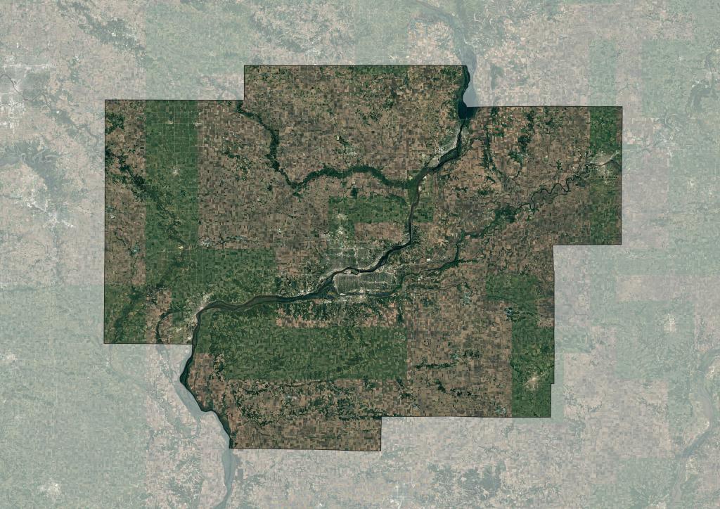
As mentioned above, Euro-American settlers converted nearly all prairie and wetland into farmland, and this land use continues to dominate the QC Region landscape today. Essentially, wherever one sees a field of corn or soybeans, it is safe to assume that that land was likely once blanketed by prairie grasses and wildflowers. We are lucky to retain a small handful of prairie remnants in the region (click here for a list of QC prairie remnants) which allow us a tiny glimpse into the history of the QC landscape.
Similar to prairie and wetland, virtually all wooded land, although not usually ideal for farming, felt the impact of Euro-Americans, as well. They logged the trees of forests, woodlands, and savannas for building materials and fuel in addition to using them for grazing. Luckily, tree cover in the QC Region, in many instances, has rebounded since this period of cutting, and we retain a few higher quality areas of woodland. Sinuous bands of canopy can be seen along river, streams, and on dissected bluffs in satellite imagery. The corridors of the Cedar, Wapsipinicon, Rock, and Mississippi rivers are strongholds for woods in the region today.
References
- Illinois State Geological Survey. (2003, August). Illinois Landcover in the Early 1800s. Retrieved January 21, 2023, from https://clearinghouse.isgs.illinois.edu/data/landcover/illinois-landcover-early-1800s
- Patrick Wilke-Brown, State of Iowa. (2017, December 4). Historic vegetation (GLO). ArcGIS Hub. Retrieved January 21, 2023, from https://hub.arcgis.com/datasets/iowa::historic-vegetation-glo/about
- Wikimedia Foundation. (2022, December 19). Public land survey system. Wikipedia. Retrieved January 21, 2023, from https://en.wikipedia.org/wiki/Public_Land_Survey_System

Leave a comment